วันอาทิตย์ที่ 15 มกราคม พ.ศ. 2555

Mu Ko Similan


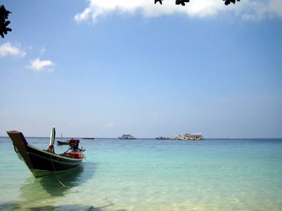
Similan Islands National Park. Located between latitude 8 degrees 28 minutes to 9 degrees 15 minutes north of the intersection of longitude 97 degrees to 97 degrees 50 minutes East. In the Andaman Sea. The Indian Ocean. The Similan Islands National Park. Stay away from Thap Lamu pier. Muang district of Phang Nga province, about 70 kilometers away from the pier Patong, Kathu, Phuket island, about 90 kilometers Myung-or four islands are located.
"Similan" is the language of the Muslim world means "nine" is a name known. Mu Ko Similan or Ko nine consists of a large island or 9 island by island, nine aligned along a north to south and Koh Bon, Koh Ba Snake Island, Similan Island Resort in Koh Ha, Koh Myung Island Resort mock The Island Resort and Koh Hu Yong.
Similan Islands. Has been declared a National Park of Thailand, No. 43 in the year 2525 an area 128 square kilometers (80,000 hectares), and in 2541 was annexed area, "Koh Ta Chai," added another 12 square kilometers. Into a national park covers an area of ​​the island and the sea waters around the island with the reef. Local Phra Thong Island. Kuraburi, Phang Nga province, a total area of ​​140 square kilometers (87,500 acres) of land area, the island is about 26 square kilometers (16,250 hectares) coastal islands in the Similan Islands. The eastern part of the Andaman Sea. In the Indian Ocean that have been cut down to the sea floor (SUBMERGENT SHORELINE) has been eroded by the sea erosion is a serious cause of the nine islands of the island is a strange landscape. There are different shapes. As a result of erosion processes. For rock found in the Similan Islands and the island is nine kinds of igneous granite rock under the age of the Tertiary - cretaceous about 65 million years ago.


Image from:www.worldwidegrp.com
Image from:www.kiriwongtour.com


Chaiyaphum

Pasture land of beautiful flowers Krachiew. Waterfall juiciness when the rainy season. Vast forests and rich variety of natural sources Khieo. The wonders that nature created to monitor white stone.
The Gallery is a province that has an exceptionally high tourism potential not inferior in the Northeast.
Gallery is located on the ridge east edge of the plateau. The contact with the central and northern areas. With an area of ​​approximately 7,986,429 acres or 12,778.3 square kilometers. Is the largest province of the country's topography consists of seven hills, forests and 50 per cent of the province. Mountains scattered from east to west. The major mountain range, Phu Phu's old Lancashire and Phu Chi River crash warped, which is the origin. Outside the plateau. The province is in the middle of the plains.
Of history. I have read multiple overlapping civilizations. The Dvaravati period from the influence of Cambodia, Laos, Lan Xang. Ancient monuments and antiquities have been discovered in many areas of the province. Later, the name of a city in the Ayutthaya period. In the reign of King Narai the Great. The status of a city of Nakhon Ratchasima. Contact with the city. Subsequent to the divorce.


I read the name again in the early Rattanakosin period. Meets the King of La sky. The inhabitants of Vientiane. He has been a leader. The Wildcats took a foothold in an area called the Non water indirectly. And continue to use cities as it is read.
In the reign of King Rama I to proclaim 2369 as the world's subfamily rebels attacked army troops into the city of Nakhon Ratchasima and provinces along the way I read it, then ruler of the hosts are joined with the modern lady. Beat the army of his defeated the subfamily Vientiane. King Rama I to proclaim that He graciously pleased. Khunying Mo is the Thao Suranaree. Then the prince and his loyal assembly Read the next ruler of a loyal prince descended from Chumphon (then) that the prince was still a loyal Rachtinnam meeting
Gallery is divided into 16 administrative districts namely Muang district size. Bganekwga district. Conswrrcs district. Ekษtrsomborns district. Bang Bang Bua district Bmehnehnrgcs Khieo Square district. Bganแten district. District Kangkraw Kon Muang Nong Bua district Thepsathit chasm between. Loyal to the district assembly Its elegant district. And sub-district head.


Image from:www.isangate.com
Image from:www.iam.hunsa.com


Phetchaburi

Wang, with his house. Sweets in his inimitable art, dance Dharma ocean beauty.

Phetchaburi is situated on the southwest of Bangkok. As key areas of central and south. Is well known as a source of sugar. Because of the sugar density. It is also a major tourist destination.
Bangkok has many famous tourist attractions and a variety of formats. It is not far from Bangkok. The province is one of the tourists, both Thais and foreigners. The most popular vacation destination.
Petchaburi Province with an area of ​​about 6,225,138 square kilometers or approximately 3,890,711 acres and a province as large as the 36's with the widest in the east - west, a distance of 103 kilometers and the longest in the horizontal direction. North - South, a distance of 80 km.
Topography of the area is divided into 3 locations in the western mountains and highlands. A mountain range stretching from north to south. The origin of the Phetchaburi and Pranburi River. The river plains in the middle of the province. It is the most fertile areas and agricultural areas of the province. The New River flows through. The Kaeng Krachan dam and dam locations. And the coastal plains to the east. Coastal areas of the Gulf of Thailand. The total length is about 80 kilometers rich in mangroves and beaches. A major economic province in terms of fishing and tourism.
Bangkok is a city with a long history over 2,000 years since the Dvaravati. Formerly a center of Buddhism. The name used to refer to different foreign countries, such as the Dutch called "Print Gallery" The French call it "Print Peak Oil" and "fish free" to assume that title. "The pre-flash" is the original name of the city of Phetchaburi. This is consistent with the blink of a sacrifice. The old temple of the province.


During the Sukhothai and Ayutthaya. Phetchaburi is an important outpost in the western provinces. New parents have a ruler who is dating royalty. Later in the period. Phetchaburi is a city of travel. King Rama to his favorite city of Bangkok since the tonsure. When he ascended the throne, so please have built a large temple and pagoda on a scrub. Close to downtown. And be called "Phra Nakhon Khiri".
Later in the reign of King Rama V. Please provide a royal palace in downtown Bangkok and another is "Rama Palace," also known as "the home of Wang Gun" and His Majesty King Rama VI had to be built. "Palaces Maruekhathayawan" on the beach later. For use as a residence for his treatment. Also believes that Sea, air and water may help relieve illness. Phetchaburi province, it was called. "The three-Wang" ever since.
Phetchaburi province is divided into eight administrative districts are Muang Phetchaburi, Cha-am district Ekaigai Hnaghygaplgag District District District Bganlad Yang Ban Laem district. The Kaeng Krachan.


Image from:www.raktrip.com
Image from:www.arissarayengen.blogspot.com


Ko Si Chang

Ko Si Chang island is big as a district of Manila. Sriracha, about 12 kilometers away from the ship at the International Airport. The island's tourism and local atmosphere. You can drop in any one day or stay overnight. The east side of Koh Si Chang community. The Bank is located at Wong (at the bottom), and as a starting point to travel by tricycle or Skylab to other spots on the tourist spots on Koh Si and Si Chang.
Khao Yai Shrine. Located on a hill away from the pier to the north of the island's evil family. Ko Si Chang is a holy people to respect. The caves, which are converted into places of worship. A blend of Chinese and Thai architecture. The front of the house overlooking the island.
Buddha Footprint. Placed high up on a hilltop shrine as he brought his reign of five enshrined. He is a top view of the surrounding sea.
Hell Fire Pass Memorial, located on the back of the island. If a boat ride through the gorge. In view of the bridge for walking. You can watch the beautiful sunset beach, round stone, which is filled with rounded stones of various sizes in the past is the view of the pavilion at the residence of King Rama 5.
The court Jutha Tuch. Bank moves away from the family to the south of the island. Built in the reign of the fifth to be stamped in the summer. The area has a beautiful landscape. The beach front at the palace. Next to the building, Wattana. Pagnhya his palace. Wooden gingerbread patterns. Building or hall, Sri bright and pleasant octagonal building on the hilltop temple of Wat Atsadang vision of Thai architecture and construction with the West. The palace is made of teak, was demolished to build a palace in Bangkok, Wiman clouds are also other buildings include a pool, pond, bridge, pier and lighthouse.
Caves Beach is located on the west side of the island were destroyed. The wide beach. Clean and beautiful. With sand. Clean water suitable for swimming.Tourism on the island. The attractions on Ko Si Chang is well enough. It is very convenient if you rent a motor tricycle from the pier to watch the various fragments, it takes about an hour trip around the island. Rent a motor tricycle around about 150-250 baht depending on the duration and distance.


Image from:www.chalaom.com
Image from:www.www1.mod.go.th


Maya Bay


Maya Bay, the same process occurs with a nice spin to the Gulf. However, part of the surrounding cliffs, erosion has become a large open space connected to the sea. Water flow in and out just fine. Limestone islands of the coast are located tens of kilometers. Sediments from the Bay has very little influence. Clear water allows light to pass in the appropriate Coral larvae are swept across the island to take on the rock pile in the middle of the bay. Once entrenched it. Asexual reproduction of each split into two, one ... two to four. Over time, thousands of years. Scale-covered coral at Maya Bay. At the same time the sea has changed. Natural processes also occur on the coast. Sediment was deposited as a sand beach. The coastal vegetation floating on water. With some animals grow a wild beach. Occupying about 50 acres in the Gulf.

Maya bay. With an area of ​​refuge in the mountains about 250 meters long, the part was designed by nature to be 5-15 m wide, sandy beach areas as soon as they stepped down from the ship and walk onto the beach. I feel that This small piece of beach land. It's soft and white feet. The pupils have to stay down so far from the sun that shines on the mirror sometimes. If I go back. The brilliant luminosity. Enืgatrai a soft, fluffy sand at the foot of this Are a consequence of. The remains of the coral was destroyed and ruined. Crushed into fine powder. The cycle of nature. In the end, to be tossed by the waves splashing up from the pile for years.
The arrival of the international team filming of "The Beach" has become a major cause of change. Almost every field of media. I took the news of the film, moreover, Mr. Leonard said in The Laguna is shaking the world in the role of "Jack" from the movie "Titanic" as the hero. Make said blow up the public's attention. The beauty of the beach. And popularity of the movie "The Beach" make each day. There are many visitors in the Gulf.


Image from:www.2how.com
Image from:www.gotoknow.org


วันเสาร์ที่ 14 มกราคม พ.ศ. 2555

Surat Thani

Hundreds of islands in the egg yolks, shellfish harvesting, food sources of Dharma.Tourism is the primary province of Surat Thani. One of the country's provinces. It has natural beauty. Koh Samui and islands like Koh Samui, Koh Tao, Koh Nang Yuan. And an area of ​​tropical rain forest on land that is rich in diverse vegetation and wildlife rich waters.

Surat is also fully equipped with all the modern facilities. With convenient transportation via bus, train, ship and is home to two of the airport to increase capacity to accommodate visitors as well. Until now, tourism has become the center of the southern coast of the Gulf of Thailand. The tourists, both Thai and foreign visitors flock to the millions of people each year.
Surat Thani province, an area of ​​approximately 12,891 square kilometers or 8,056,875 acres, a province as large as six of the country and the largest of the South. There are a variety of terrain, from the islands of different sizes. In the Gulf of Thailand coastal plain of the mountain plateau. And river plains. The river is the river Tapi River and Chaiya. There are approximately 156 kilometers long coastline.
Surat is a city of old has been since prehistoric times. The indigenous people are just normal and traditional Malay. I live in the watershed (river Tapi), and Ban Don Bay Area. And from the discovery of traces of civilization, Srivijaya, Chaiya District. And found traces of the old city, many areas around the bay of Ban Don Muang Thong Kanchanadit port cities and towns Punpin Ewiyongsra. It's in the city was the capital of the kingdom of Srivijaya, Chaiya in the past.
The deterioration of the Srivijaya Empire. In the city, this city is split into three port city of Chaiya, gold and Kiri in the state. Under the rule of Nakhon Si Thammarat. Match at the Sukhothai in the north is flourishing. And expanded powers to the south to Malaya. Chaiya city, it falls under the rule of Sukhothai and Ayutthaya at a later time.
Later in the reign of King Rama 4 cities in the world weakened. While Don has been very prosperous. We are dealing with international trade. So ordered. The home port for gold to move inland. And raise a quarter of the city directly to the City. The new town was given the name "Kanchanadit" But when the provincial government Etsapibal. So ordered. The whole city Kanchanadit (Don), city and town Ciriraฐnicm Chaiya as "Muang Chaiya".
Later it was determined that a district which is home to the city hall as the "city" Don Hall is the location at that time. It is. "York City" means city of good people. The province will be received. The city Chaiya was cutting the word "city" out only "Chaiya" from the district of Surat today.
The Surat district is divided into 18 districts, is a sub-district, Muang district of Surat district Punpin Khiri district of Phanom district Kanchanadit state. Don Sak, Koh Samui district, Chaiya District Thachana Teaฉag District District District Bgannasar sword Ewiyongsra District District District County Bgantakun Kian. City district. Chai Buri district, district and subdistrict Bgannaedim Viphawadi.


Image from:www.thailog.org
Image from:www.attractions-inthailand.blogspot.com


Chumphon

Southern gateway. Coffee prince worshiping the beach here is a fingernail. Up a nest.
Chumphon, the gateway to the south. Dan and cities in the former city of 12 zodiac is endowed with natural resources. The forest and the sea, as well as a bridge between the Gulf of Thailand and the Andaman Sea. Which is relatively hard to complete everything in one place. County to try and get to know a little bit. I know it is not uncommon.

Provinces with an area of ​​approximately 6010 square kilometers. Topography of the western provinces are mountains and mountains of Phuket is a barrier Tanaosri border between Thailand and Myanmar. There are areas of low slope from west to the area. East of the mountains and forests. The watershed is the source of the river a short line as it winds. Nam Lang River Suites etc.
The central area of ​​the province. The undulating plains and river plains. There are plenty high. Suitable for cultivation. Meat, about 1 in 4 of the land area. The east side is a plain along the Gulf of Thailand. The beach is quite flat. The concave curvature is small and very beautiful place and the main attractions of the province.
Chumphon has appeared since the year 1098, with an outpost of the city of York. Using goats as a badge city. A town in the southern kingdom of Ayutthaya in the reign of Her Majesty's land Trailokkanat. In the reign of the fifth King County to establish a territory. Later, with the collapse of the regime governing the province. County are as a province.
The word "County" are derived from the word presumably comes from the word such as "general assembly" as is Dan. The troops will come from the north or the south. I have gathered together to set up camp here. It may come from the word meaning "gathering together" because of the war to the generals said the ancient past. When I move to send troops to worship a sacred ceremony. I won the battle. Bmrugkwany the military. In a gathering place to get together like this. With a rally at a meeting with the other hand, assumes that I come from a variety of natural wood and the fig tree in the local County. The County is home to the city on the banks of the river at Cochin. The fig tree was a lot of Chumphon. The fig tree is a symbol of the coat of Chumphon Chumphon.
Chumphon province is divided into eight administrative districts namely Muang district of Chumphon Lang Suan district Sawee Thasae Thiew District District District Laแm Phato Thung Tako district.


Image from:www.gotravelstation.igetweb.com
Image from:www.travel.mthai.com


Udon Thani

Water falls from the ridge of Phu Phan. Park News. Five thousand years of civilization. Mee Khit Thani fabric. Magic Kingdom seemed pus. Fragrant orchid looks good times Aฌ the Crown.


Udon Thani is a province that is a hub of transportation and travel north-east of Thailand. Is especially important in the history. Due to the location of Ban Chiang civilization. The traces of human civilization, the oldest in the world.
In addition, New York also has many natural attractions. Making crafts to local communities such as Khit lifestyle simple, charming, typical Thai community east. Cities and places. There are plenty of hotel accommodations. And communications facilities. Especially with the airport. New York is another city that travelers should not miss to visit.
Province, about 11,730 square kilometers in area, or about 7.33 million hectares of the province with the largest 11 of the general topography of the plateau. Consists of fields, forests and mountain areas, slope angle into the Mekong River in Nong Khai province. West there are mountains and forests consecutive linear The mountain is Phu Phan mountain range. Fry is the length from the north and the south end.
Province has a long history. Archaeological evidence shows that the discovery of the province today. Human communities living there since prehistoric times, about 5000-7000 years ago, an ancient community with a high level of civilization and prosperity. Assumed that the lines of pottery found at the Ban Chiang. The lines may be the oldest pottery in the world.
Communities living in this area later. But this is only a small community. No role in history in any way. In the year 2428 until the reign of King Rama V's reign, the Royal Family, she ordered five thousand of them seemed sharp and Spa here, I want to be the Nat. Troops to suppress them in the province, Laos, Hong's left bank of the Mekong River. The combination of terrorism. Arts Club of thousands of proven quality. Commander of the South. Has led the army through a region which is home to the province today. And to perform well against a walnut. In the communities of New York is a small village called "Ban Hmakแkgg" or "Ban Dua Hmakแkgg" under the rule of Nong Khai Province, Lao PDR, which depends on cable


Later, the dispute Rs 112 (December 2436) between Thailand and France. Thailand and the Mekong River to land the left side of France. Siam Treaty have allowed the troops and fortifications within 25 kilometers of the Mekong River. Military forces stationed in the town of Nong Khai. The Arts Club of thousands seemed sharp as the High Commissioner for national success. Retraction must be moved to the home Hmakแkgg Dua. The Department of Arts and spa crystal clear I would set up the province, Laos, and new troops at the village.
Later, King Rama V ordered the establishment of "county times" more at home Hmakแkgg. The government has amended regulations. Termination of government in the province Etsapibal. Udon Thani province, was to dissolve. And change it. "Province" ever since.
The province is divided into 18 administrative districts and sub-district, Muang district, Udon Thani 2. Board index Nong Han District District District District District Dung Kumpwapi Phue home. District Department Ngmosom Onnsaaad District District District District Kudhab Sritatu Vangsammor district district district created Tuegฝn Nong Saeng District Amphoe Na Yung District Achiwan Pibul Conservation District. Ku Kaew sub-district. Arts facilities and sub-district seemed sharp.


Image from:www.news.edtguide.com
Image from:www.nongsangplace.blogspot.com


Trang

Rassada city prince. Public-minded citizens. Delicious pork roast. Native rubber. Its elegant flowers Trang. Coral Sea. Attractive beach beautiful. Pretty spectacular waterfalls.
For those who love the atmosphere of the islands and coastal beaches, delicious food. I do not think Trang. City or over lunch. Prosperous trading port from the past. And continued to the present time. The accumulation of history, passed on to the many tourist attractions such as museum artifacts Mahisorn loyal prince Rassada support.
And the known. Trang was the first territory to which the rubber from the rubber tree planted today is an important cash crop of the South. Income people to sustainable living. Not only that. Trang also include an abundance of water resources, forests and caves, large and small. The major attraction of not less than a sand beach and the islands at all.
A visit to the province so that all travel tastes. The land of life, natural history, with appropriate facilities and sufficient in each place where you go.
Trang has a total area of ​​approximately 4941 square kilometers. Most areas are small hills interspersed with low hills plains. It is assumed that the name came from Trang, the word "my, Trang" in Pali, which means wave. The area of ​​the province. While the presumption is that Trang from "Trang K.," Malay means "dawn" or "light up" because of the past. Ship will sail from Malaya came to light when I Trang.
The city of Trang in the initial time period. The evidence is written in the Sema. Nakhon Si Thammarat. Which stated that Trang is the cities that made the city of York. And other evidence. At a later time. The era of the evolution can be divided into three periods is Trang.


1. The district Kuan Thani town (2354-2436 BC) corresponds to the reign of King of La sky. Evidence from the House that the Department of Industrial Ap Trang and Surat Thani Trang governor first. A city at the Kuan Thani. (Located in the district Kantang today. Away from the city to the south 8 kilometers).
2. The city is Kantang (2436-2458 BC) corresponds to the reign of King Rama V. Prince of this invention Rassada Mahisorn loyal support (neck Sim Bee Na Ranong) the position of ruler. He said the city was Kuan Thani is very far from the coast. We respectfully ask the city to relocate the District Kantang. It is a great community. Chinese to live a lot. In support of the prince Rassada invention Mahisorn own loyalty to the ruler of Trang have been developed such as the introduction of the Malayan rubber trees planted for the first time. The road from Trang to the high price. A port for trade with foreigners, etc. It is a very prosperous period ever.
3. I set out over the city (2458 BC to the present) prior to the reign of King Rama VI. Which corresponds to the first World War was a Royal. Kantang urban areas are not safe from the United States was the enemy. Moreover, an outbreak of fever, cholera He graciously pleased. The city is located in the district over the meridian. Which is located in Muang District, Trang, sure enough.
Trang Province is divided into 10 administrative districts namely Muang district, Trang Bang district, Huay Yod district Kantang Ieantakaw. Palian district of London in the district of Mae Wang wonderful Rassada and the District of beach fun.


Image from:www.talaytrang.com
Image from:www.ok-thai-trip.blogspot.com


Suphan Buri


Iuthheete Thani town. Literature up. Celebrated here. Prosperous agriculture. History is exceptionally high. Primary sources of the artist. I listen to dialect.Suphan big producer of rice in Thailand. The city has a long history. A tourist attraction. The city is equipped with facilities. Road comfort. Can travel to destinations across the province with ease.
Suphan rich history, culture and tourism, nature has come to Suphan Buri is considered to be a memorable experience ever.
Suphan Buri province, an area of ​​approximately 3,348,755 million hectares or 5358 square kilometers. The plains suitable for cultivation. The flow of the river nourishes the people in Suphan Buri province.
Suphan Buri is an ancient city. Archaeological evidence found at least 3500-3800 years old artefacts excavated a Neolithic and Bronze Age and Iron Age cultural heritage since the airport Funan Amrawdi Dvaravati, and Srivijaya.
Suphan Buri was called Dvaravati Srisuphanthavorn landscape. Or were the rooms. Located on the banks of the Tha Chin River District, a fence around the big red record Bihar district. The Lord moved in each city is located on the right bank of the river. Please allow at least mon to build a temple at the finish. Lake Forest Ali and restored function. Persuade government officials, 2,000 people have dubbed the new town ordained that two thousand rooms.
Times to the reign of King U-Thong. A southern or western city of Tha Chin River. A city called Thong. Please select a destination place until the sill. This city is known as Suphan ever since.In the Ayutthaya era. Suphan Buri is an outpost in the city and is the big producer of rice. Through several wars. The ancient town was destroyed, leaving the ruins. Up to the time period. Suphan Buri is a newly recovering city. And is located on the east bank of the Tha Chin River. (Suphan River) as long as until today.
The importance of Suphan Buri in the history of independent salvage Thai Ayutthaya period and the victory of King Naresuan the Great War Iuthheete that he has a victory over the battlefield at Don Chedi Phra Maha Raja equipment. The great bravery and great channel strategies that have been inscribed. And a great event to celebrate every year. To honor.
In the literature. Is the origin of the legend. "Khun Chang Khun" which appeared in the context where it is still seen today as the home of the fence at his Lake Forest, ten premium cotton masks the Capital District U-Ali district Sriprahants.
Suphan Buri district is divided into 10 districts namely Muang Suphan Buri. Bagplamga district. Sriprahants district. Don Chedi district. Edimbagnagbwch district. U Sam Chuk district. District swamp grass site. District two brothers. Danchang district.


Image from:www.sakid.com
Image from:www.guidesom.diaryclub.com


วันศุกร์ที่ 13 มกราคม พ.ศ. 2555

Rayong

Fruit flavor, exceptionally tasty sauce advanced industrial island beauty. Soonthornphu poet.

Rayong has been dubbed as the city of Rattanakosin poet "Soonthornphu" The scene in your story was. His forgiveness is a gem. The islands, large and small. And the beautiful waters of the province of Rayong.
Besides the natural beauty of the seaside city of Pattaya has become one of the region's countries. Rayong is also home to important fisheries and seafood production. And a source of growing fruit quality. It is an industrial city and is home to the Eastern Seaboard Development Project. The new economic zone of the country.
With a great location. Not far from Bangkok and Suvarnabhumi Airport. With convenient transportation. Rayong province today is another popular destination of tourists looking for comfortable living. I still have contact with nature and the atmosphere that is together.
Rayong Province, an area of ​​approximately 3552 square kilometers or 2,220,000 acres, a province as large as 45 of the country, the area consists of approximately 100 kilometers long coastal plain that slopes to the coast and hills and mountains. The mountain area Chamao east. And mountains in the center of the city as the city's long. To the north end of the province.
In the district of the city. There are two major rivers, the line is long, about 50 kilometers, Rayong River flows into the sea at Tambon Pak Nam. Muang District. The Square and the river's length is about 25 kilometers into the sea at Tambon Pak Nam Klang district in the Square.
One of the ancient city of Rayong. Assumed that was founded about the year 1500 in an era where we have the power to Suvarnabhumi. As appears from the evidence remains of laterite. Pairs remaining in the district's Bankai. The construction of Khmer art.


Around the year 2309 in the reign of doctoral students of Ayudhya. During the Ayutthaya near Bangkok to Myanmar will be the second king or prince Wachiraprakarn dried with approximately 500 armies breakout hit Burmese people have come out. And break before marching to the city of Rayong, Chanthaburi. To hold a collection of soldiers to return to salvage the freedom of Burma in the year 2311, by the time he was in Bangkok was established by the Navy.
Today, the city of Rayong is still very much revered King Taksin. It is evident from the fact that people come to worship his statue at Wat Lum Mahachai Chumphon. In a lot of Rayong. The city is also a major road in the town of Rayong. "Taksin the Great."
Rayong villagers mostly descended from the Cambodian fields with China. The rest are Chinese and the Beach. Speaking of the box will have a tone of "The Hills," which means "Yes" or "I" is the identity of Rayong. The well-known throughout the country today.
The city name "Beach", the distortion of the word "cool to be in" the language field. There may be a means both of the territories or wood Du.
In the past, Rayong district is divided into 3 counties and Khai posture Du Du Port Klang later, the district has a population of less. I collapsed into Ta Du. Depending on the city of Rayong. Klang district that was once the province before. It has a very small population. Later, as the district has been reduced to the province of Rayong.
Rayong province is divided into eight districts and territories, Muang District, Rayong Ban Khai District of Rayong district Pluakdaeng Wang Mon Khao Cha Mao. And Industrial Development District.


Image from:www.travel.mthai.com
Image from:www.travelinthailand2.blogspot.com


Sa Kaeo

Primary forests, beautiful waterfalls, beautiful Burapha border with patches of ancient civilizations. Commercial district, Thailand - Cambodia.


Any new province is separated from the province of London. Located on the eastern border. There are many other historical sites and antiquities. And its rich natural resources such as Pang Sida National Park and Ta Phraya National Park.In addition, Health is a natural sculpture as "a group" that looks strange. And the border district of Aranyaprathet. The big door that opens into the Kingdom of Cambodia. Communication links between the country and travel to the same path. The salt has a market full of cheap and second-hand goods from neighboring countries.Any area of ​​approximately 7195.138 square kilometers, or about 4497 ​​acres and a province as large as No. 28 of the country is located along the eastern border of the country. The border with Cambodia, about 165 km east of the plains, plateau and mountain areas of high complexity. The average height of 74 meters above sea level, with mountains in the upper line of the province. The origin of the winter. And a dense forest in Pang Sida National Park. The hillside to the south plains. There is a sparse condition deteriorated. Most of the invasion and reclaim the land. The eastern plains to the highlands. The condition is sparse. The west is the watershed. And slope to the District Health and Aranyaprathet. Continued into the Kingdom of Cambodia. The central part is a flat area of ​​the district and the Wang Nam Yen and Wang.Sa Kaeo is located on the eastern border. The city has a long history of 4,000 years since the Neolithic. The artifacts have been discovered in the district of his critically Aranyaprathet. Ta Phraya district. As evidence that this area was a community that has flourished in the era of Jane and Dvaravati. Civilization and culture as their own. A king or ruler of the city's Hindu religion. As the Anglican and Roman Catholic doctrine Awษnp. This can be seen from the ruins and inscriptions written Palma Lwa. That appears in the castle, he is less. Aranyaprathet district. It is said that the era of the oldest recorded evidence of the inscriptions found in the first edition. Built around the year 1180.They also found evidence of the prosperity of the Buddhist civilization in this region many centuries, 15-16. The castle, castle rock, brick kiln, wares and left traces of the ancient moat in the castle picture Kok Thom. Was created as a shrine of Lord Shiva.


Any water that comes from an ancient district in Sa Kaeo, which has 2 swimming pools during the year 2523 in Thon Buri. When King Rama I the Great. When the battle was the King Somdej. Troops to attack the Kingdom of Cambodia. Not stop at the pool and the second is called. "Health service morale," I have brought water from the pool and 2 are used in a ceremony held by Satya prosperity. It is holy water.But as a Health District. Is the location of entry and exit of goods. The official position of the Division serves as a checkpoint to the year 2452, the government has been upgraded in two phases. "Health district" under the rule of Prachinburi. Subsequently, on 1 December 2536 with the establishment of the province of Sa Kaew. As a result, became a province of Sa Kaeo, Thailand's 74th since then.Any divided into eight administrative districts, is a sub-district, Muang District, Haad Kaew Ta Phraya district of Klong Wang Nam Yen district. Watthana Nakhon district. Aranyaprathet. Khao Chakan district and sub-district, Wang coke completely.

Image from:www.thailandhub.net
Image from:www. bloggang.com


Chonburi

Chonburi. Briefly known as the "City of Lakes" is a city with an important seaport. For a long time hundreds of years. Until now, it still is the deep-sea port at Laem Chabang Port, Bangkok has a secondary importance. It is also a source of economically important crops. It is also home to the Laem Chabang Industrial Estate. An important role in commerce and the national economy.
In the past the seaside city of Pattaya has gotten much better. It was used as a sanatorium and resort of kings. The high number of his royalty. Appeared among the magnificent court of King Rama V King Rama 5 on Si Chang. And became a popular tourist attraction today.
Situated not far from Bangkok. And passengers. It also has many famous tourist attractions. City has a growing reputation. As a seaside resort town and province. Until it became the province's tourism industry is growing province in the region. The enormous amount of revenue to the country every year at present.
Chonburi province has an area of ​​approximately 4363 square kilometers or 2,726,875 acres, a province as large as 51 of the country's coastline indented with beautiful curves. The rock cliffs and sandy beaches, mangrove forests, beaches, and the length to 160 kilometers.
Topography of the city is diverse. The undulating plains and hills on the east side. Coastal plain estuary from winter to Sattahip. Ministry of the fertile river plains with sediment. Suitable for farming. Steep and mountainous areas of central and eastern areas of the province. To more than 46 large islands, the island that serves as a natural fortress. Prevent waves. City have made big waves. Coast City is filled with fishing marinas. And is ideal for building large commercial marinas.


The Province today. Assumed that the residential community since the Dvaravati period. The city is located in the sub-pages as relics. Pnasnicm district today is the center of the local community at that time. Due to the location of the city's water lines and water lines can travel to other communities such as urban Sri Mahosot. In London. Or even to Aranyaprathet. There is also a walking trail through the town of Paya ply. This is another important ancient city in the area. To Rayong and Chanthaburi with
Later in the Sukhothai period. Community plan was developed at the mouth of the river is named "Si Lo's" is a sea port with foreign junk from China, Vietnam and Cambodia are popular free product before your next trip to the mouth of the Chao Phraya River. Or stay and park before crossing the Gulf of Thailand to the south. It appears that the Chinese descendants still live in many locations in the city today. And is the largest Chinese community in the East. The slope of the Great Wall of Si is destroyed during the construction of Sukhumvit Road. Archaeological evidence in the area to remain very low at present.
To the early Ayutthaya period. The metallurgy in Sri ants are important because the bay was once a shallow sea. Due to the deposition of river sediment. Community is gradually Move down south. And to build a new city district at Bangplasoi. (As the city of today), which has its beaches and marinas, the better.
In the reign of King Rama I to proclaim the reign of the third Aaษa the north of Vientiane. It took just one of the Royal Lao Optisompar. So ordered. Laos to allow those living in the area between the city of Chonburi and Chachoengsao. And later incorporated as a city Pnasnicm community. Until the reign of the five cities and towns Pnasnicm Banglamung district collapsed. Directly to the city of Manila. The district of Chonburi Province had since then.
Chonburi province is divided into 10 districts and territories, including a sub-district, Muang District, Chonburi. Nong Yai District. District Pnasnicm Banbueng Panthong district, Sriracha, Banglamung District Bothong Sichang Sattahip district. King Island District and Mon The City is under the management of local government called a special city, separate from the administration of Pattaya.


Image from:www.cmadong.com
Image from:www.travel.kapook.com